12/4/11

Building an (internet) running base

Time heals all wounds so they say, but I've always viewed extended breaks from running with disdain.  I haven't really needed or taken one since I started running consistently in 2008, but I have also not dealt with shin splints on the level at which I incurred this year.  In the 2 months prior to Javelina Jundred (km) I olny managed a dissapointing half of my preferred weekly miles (25 mpw vs 50 mpw).  To really heal this up for the 2012 year I've been taking time off from running, 3 weeks so far, and 1-3 more weeks expected.  I'm apprehensive about how those first steps will feel when I get back to it.  If my shin still hurts I will have to add another month off and then reassess.  The long term goal is to toe the line at Burning River in late July in the best shape I've been, and make an attempt at a sub-24 finish.  I haven't decided fully on this race though, there are some other ones in the Midwest that look interesting, including Mohican, but if the injury takes longer to heal than I currently expect I will also look at Georgia Jewel in late September, or Ozark/Pinhoti in early November.


Saturday afternoon bike ride in December?  Yes, please.


Having said all that I am not actually frustrated with so much time not running.  It feels like an investment in the 2012 running season, and I've found plenty to do between yoga, crossfit (3x per week now), spin and road cycling.  Since the road cyling around here is so pleasant, I'm also looking at trying my first century (road cycling 100m)  next fall.  It's something thats been on my five year plan for at least a few years.    Trail running still appeals to me far more than anything else so I have of course been keeping up on my internet running by following yesterdays race in Marin and making up a calendar of races to look at.  I'm patiently excited for 2012.


Three Saturdays worth of rides in the country outside of Bloomington

11/20/11

JJ 100 (km) race report


Somehow I managed to muddle my way through the Javelina 100 (km) race last weekend despite an almost complete lack of training.  The course, the volunteers and the organization were amazing at this event.  It was really a spectacle.  Camping the night before at the start line, we were awakened numerous times the calls of coyotes.  I was really excited to spend the entire day in the desert.

After 1/2 hour of running in the dark, the sunrise did not dissapoint.  The scenery was amazing in the morning light and somehow my shins were not hurting.  As an aside, if I ran this race again I would not carry a headlamp to begin with, if it's not cloudy out there will be plenty of moonlight.  I felt good on the first lap, the rocky section up was fun, the rollers even more fun, and I managed a good constant tempo back down the slightly boring double track no the way back in.  On lap 2 I saw a giant tarantula on the dirt road and struck up a number of interesting conversations which made the time go by quickly.  Starting lap three I felt absolutely great, I was excited by my 'time bank', always a dangerous notion, but I quickly began to  fatigue, in my hip flexors especially.  As the lap wore on my overall run/walk balance listed dangerously towards the latter.  I muddled my way through a good chunk of lap 4 before sunset.  I never ran another step after it got dark.  Ugh.  I get so tired after sunset, I am not sure why, but the same thing happened to me at Western States last year when I zombie-walked my way down all of Cal St.  No matter, I finished  my first 100m that day because that is what I set out to do, and I was in good shape to do.  I did not feel like walking the last 50 mi this race, so I called it quits after the 5th lap.  For me there was no point to walking in the 100 mi, when I was perfectly happy to have finished the 100km.  

It was fun, it was a great race and (before the sun set) I enjoyed myself thoroughly.  Since its raining cats and dogs here in Bloomington IN today, I put together a few plots illustrating my day.  Many people took the 100km option, probably half of all drops occurred here.  Darkness and the onset of rain were probably important factors. 


Fig 1:  Attrition rate vs lap number.  Each lap is 15 mi, except the 7th, which is 10 mi.  Attrition rate is defined by percentage of people finishing each lap (click to enlarge).


Fig 2:  Cumulative time at 100km binned by time.  All runners are considered, whether they ran 100km or 100m.  I ran a 14:28, putting me right in the middle of pack (full results here).  The 14:28 is a 1 hr PR over my only other 100km time at Waldo 2010.

I got much slower with every lap, presumably due to my poor training.  Why was my training poor?  Shin splints.  I battled with them for about 2 months this spring, but they went away and I was feeling great for months all summer, including when I signed up for race.  Then they came back, with a vengeance.  I ran ~25 miles per week for about 2 months before the race, except for the week I ran around Mt St Helens.  It just wasn't enough.  Alternatively, my tapering was fantastic, and my shins did not hurt all race.  The long and the short of it is a prescribed 1 month off of running.  I'm at the 1 week mark right now, its not so bad, not so great either, but I am keeping busy with yoga, lifting, swimming, spin class and road cycling.  It's a great way to see the country side and I might have to finally do a century ride next summer.   


Fig 3:  My lap time vs lap number.  Lap 5 = zombie walk  (click to enlarge)


Race-wise, I'm not sure if I'll be doing a 100 miler next year.  I've considered Burning River in late July, but I really enjoy the 50 mi distance.  It's easily my favorite.  I'm mulling all this about in my head as I ponder what 2012 will be like.  What I do know, is that 2010 was a great season of running because of the successful buildup to WS100.  I was strong and consistent all Spring, and I toed the line at WS in the best health I've ever been.  Ideally my 2012 season will consist of the same, with the emphasis on consistency and injury free running, even if my mileage is a bit reduced.  I'd like to experience that 'best shape I've ever been in' feeling again, and that's why I'm taking a month off to heal this nagging injury.  Internet running and 2012 planning will have to suffice for a bit.   


11/5/11

Jogging in the Jura: an overview

Jogging in the Jura:  An overview

Summary
Easily accesible from the major cities on the Western Swiss Plateau, Geneva, Yverdon, Neuchatel and Biel/Bienne, the Jura mountains form a natural border between Switzerland and France.  I spent the last year living in Lausanne, and over the course of 6 months or so managed to run the southern half (or 2/3) of Jura mountain range in Switzerland considerably.  If you are looking for information on a distance hike or run in this area I hope you might find this post useful.  My intention is to give you some good quick ideas about quality distance routes in the Jura:  which features are really nice, and which parts are forgettable.  
 
I’ve organized this post as follows:  a short summary (and link to) of specific routes, from South to North, with recommendations for shorter hikes or longer distance connections where appropriate.  I’ve also made notes about nice climbs, routes which traverse the crest,  and routes I haven’t done but would add next.  The route information given below and in linked posts is skewed towards getting to/from trailheads from Lausanne via the train, but people with cars and those who live or vacation in Geneva, Nyon, Yverdon-les-Bains and Neuchatel will also find useful information here.

When to go
The best time to head to Jura crest is just after the snow melts and just before the cows go up.  In 2011 this was April/May.  The weather on the crest can be downright nasty in winter (La Brevine currently holds the record for coldest temperature in CH).  Don't go up in January unless you are particulary desperate. The smell and ubiquity of the cows can be even nastier.  Think crocus.  If you see crocus out in numbers on the crest it’s the right time.  
  
Additional resources
You can print maps from here.  Make sure to check the sections and local trail tab.  Train schedules here.  In terms of additional equipment … It’s Switzerland, you’ll never be more than 10 minutes away from a barn, house or restaurant, and all the trails are really well signed. 


An overview of the routes described below (click to enlarge)  


An overview of the routes described below (click to enlarge)

Specific sections:  South to North

La Dole from St Cergue (post)
La Dole is a worthy day trip from Geneva, and St Cergue always seems to have a nice happy vibe to it.  The radar ball on top and shear rock face near the summit of La Dole make it easy to spot even from Lausanne.  There is a very nice unforested section near the top, but the route to/from St Cergue is characterized by cow pastures and roads.  It’s lacking in quality single track, but the climb up from La Rippe near the CH/FR border is not.  I would do that again.  Be sure to take in the amazing rock fences just to the south of the summit of La Dole.  I never did get a chance to head south from here.  It looks mostly unforested, and I believe Crete de la Niege is the highest peak in the Jura.  The only problem is that it most likely has to be done as an out and back, since navigating public transportation across the CH/FR border would be a hassle.
  
St Cergue, Col de Marchairuz, Crete de la Nueve, Mont de Biere, Mt Tendre (post)
Mt Tendre is a really nice destination from the Col de Marchairuz.  Actually, in between the two, the Monts de Biere area is one of my favorite places in the Jura, make sure to summit these minor peaks on your way to or from Mt Tendre.  The Southern half of this route, from St Cergue to Col de Marchairuz including Crete de la Neuve, is largely forested, fairly subdued, and not recommended compared to the Northern half of the route from Col de Marchairuz to Mt Tendre.  I climbed up to the crest from the Swiss plateau starting from Biere and starting from Montricher.  They were both nice, but the climb from Biere skirts a shooting range and includes more paved roads.     

Mt Tendre, Col de Mollendruz, Haut de Mollendruz, and Dent de Vaulion to Vallorbe (post)
North of Mt Tendre the Jura Crest trail returns to more dirt double track.  It’s not bad, not great, just sort of ‘meh’.  Things can get a bit confusing around the Col/Haut de Mollendruz, but the climb up the Dent de Vaulion (from Le Pont area) is a true Jura classic.  It’s mostly unforested and the views of Lac de Joux are unparalleled.  
  
Dent de Vaulion and Mont d’Or from Vallorbe (post)
In contrast to the Southern approach from Le Pont, the northern approach to the summit of Dent de Vaulion from Vallorbe is controversial at best.  The lower half is a maze of logging roads, and on the single track quality on the upper half of the climb is poor.  It’s mostly forested and sometimes feels like game trails, despite the ubiquitous blazes and rocks and trees.  The climb up Mont d’Or from Vallorbe also suffers from a surfeit of paved roads on the lower half, but gradually opens up to pasture near the summit.   Near the top is a metal can painted with Swiss colors on one side and French colors on the other.  How cool is it to cross this border on foot?

Vallorbe to Le Suchet, Mont de Baulmes, Ste Croixe and Le Chasseron (post)
The approach of Le Suchet from Vallorbe is long, boring and mostly paved.  If I wasn’t out the connect all my footsteps I wouldn’t have done this, and having done it wouldn’t do it again.  Vallorbe is a really quick train ride from Lausanne though.  Anyways the summit of Le Suchet is nice, and the area around Mont de Baulmes into Ste Croixe is one of the nicest parts of the Jura Crest.  I’ve gone up Mont de Baulmes on the Aigulles ridge itself (just OK, not actual singletrack so much as a suggested unconstructed route) and on the high quality singletrack which climbs up and over the ridge halfway down.  Take the latter, from there there are multiple ways to drop into Sainte-Croix, all of which are pretty nice.  Sainte-Croixe also has a nice atmosphere to it.  I like it there.

The climb North up Le Chasseron from Sainte-Croix is a classic.  There is a huge section of this trail which is unforested on the ridge.  You’ll love it.
  
Mt Aubert area (post
While the first few miles North of Le Chasseron are largely unforested and make for nice running, north of this the Crest dips down and the becomes a jumble of paved and dirt roads with no clear direction.  It’s really easy to get lost around the Mt Aubert area, and not a particularly nice area to be lost in.

Creux de Van to Neuchatel (post)
The switchbacks up to Creux de Van from Noirague are worth your time.  Nicely constructed, well used, and seemingly maintained, there is good reason this climb is so popular.  The Jura crest in this area is incredibly scenic.  Go there.  

I never did make it up to Le Chasseral, Tete de Ran or Mt Racine, but these would have been my next destinations, had I not returned to the US.  Surely I've missed quite a few local routes.  If you have suggestions regarding this area please leave them below.
 

11/2/11

Mt St Helens circumnavigation / Loowit Trail

There are giant volcanoes in the Pacific Northwest.  You can run around them.  Since Volcanorunning has a pretty good writeup of the logisitics and I'm feeling lazy, I'll let the pictures do the talking.

Mt St Helens circumnavigation on the Loowit trail - 10/15/2011.  Garmin says ~31 miles, but it runs a lot slower.  I think we (me an my wife April,  Frank and Ken were a bit faster) managed about 11 hrs.  It's a fantastic run, very accessible from PDX for out of town runners as well.  This one was awesome!


Frank and Ken navigate the lava rocks at dawn.  We started at 6 am with an hour climb through the forest by headlamp. 


A new day dawns in the WA Cascades


The first part of the trail (clockwise circumnavigation on the Loowit trail) alternated between islands of firs and large coarse lava rocks


Is Mt St Helens still on the right?  Then you are not lost.


April, Frank, and Ken navigate the lava fields.


Climbing out of the Toutle River valley was one of the highlights


Toutle River valley


This years fresh crop of Douglas Fir cones on the branch.  Really makes me miss the fresh hop beers of the PNW


April climbs up out of the Toutle Valley


The money shot.  Mt St Helens from the North.  The 1980 eruption came down this way.  Here is a nice aerial view.


April in the blast zone


Up and over Windy ridge and off the Plains of Abraham


April smells the barn


Yep.  You can run around Adams too.


The last portion of the route (4 to 5 o'clock) goes up and down a series of deep lava valleys.


More Adams


Aid Station on the way back in. 

10/7/11

Moleson and Me pt III: Leaving Switzerland


My time in Lausanne Switzerland is drawing to an end.  As I’m happily moving on to another postdoc in Southern Indiana I find myself trying to wrap my head around the running experiences I’ve had in the past year.  Thus it that for my final weekend mountain run I found myself on top of Moleson, heartrate over 190, gasping for breath, exalted in the beauty of what I’ve decided to be my favorite local mountain.


Moleson and Me


The places we run carry connotations defined by the emotions we bring to them, and experiences we've had on previous trips.  I spent the spring training for the Zurich marathon.  I probably only missed 2-3 weekends in the mountains in favor of long road runs along Lake Geneva but I’m actually not a road runner at all.  In April the mountains finally opened up and I summitted Moleson with the promise of a long and prosperous summer mountain running in the air.  My body was slowly awakening from the slumber of a cold and dark winter spent between a far too small studio apartment and a packed subway train.  I enjoyed to ridgeline so much I returned a week later to show my friends. 

The classic Moleson Teyschaux ridgline

Given that I had only 1 year to explore my surroundings I spent the rest of summer weekends all over Western Switzerland (Suisse Romande, the French speaking part).  The Jura’s, which form the border with France, the Valaisan alps, Cornettes de Bise, the Val Ferret, Les Diablerets, Rochers de Naye, Col de Lys, Pic Chaussy, the list goes on an on.  Ultimately it’s hard to not draw a comparison between the Swiss mountains and the mountains of my home, the American West.  The two could not possibly be more different in terms of our (humans) relationship with them.


Approaching Moleson from the North


I never found anything remotely resembling a wilderness in Switzerland.  In fact many of mountains here have restaurants at the top, which can be reached in the comfort of a gondola.  There are cows EVERYWHERE.  Essentially the entire crest of the Jura mountain range is cow pasture.  I grew up on the Pacific Crest Trail.  Not literally, but actually, yes literally.  I hiked days upon end entering and exiting one wilderness after another.  Wilderness is the most important idea in the world, not tax cuts for the rich, not medical care reform, food aid to Africa, Saudia Arabian women behind the wheel of a car, Greece’s financial obligations to the EU, or the rise of China


Descending Moleson's eastern switchbacks


The concept was invented in America, literally.  In the 1800s, it was essentially invented as an idea and then a state institution by a Scottish immigrant named John Muir to whom we owe so much of our legacy.  The American Wilderness Act was passed into law in 1964.  It reads

“A wilderness, in contrast with those areas where man and his own works dominate the landscape, is hereby recognized as an area where the earth and community of life are untrammeled by man, where man himself is a visitor who does not remain.”

Amazing.  In the American West it’s almost by default that we accept the idea of a wilderness.  It’s our legacy.  In Switzerland, at least as far as I can tell after an entire year’s worth of weekends running in the mountains, wilderness does not exist at all whatsoever.  One is never more than a kilometer from the nearest restaurant, furnicular train, cow, or electric fence.  Nature has ceased to exist outside of the scope of human economic enterprise.  The mountain meadows have been grazed so long that ‘pasture’ has simply replaced the word and meaning of ‘meadow’.  The physical effects are obvious and ubiquitous.  But what works beneath the surface is insidious and dangerous.  Nature has taken on a different meaning for many Europeans.  On a continent where the idea of wilderness has for the most part been lost for many many generations, ‘nature’ has come to encompass agricultural and pastoral activity, simply because there is no other alternative.  I could go on about this forever, but actually I prefer to think instead about what and incredible idea we have back in the American West.  Wilderness.  A healthy relationship with our mountains.  Thank you John Muir.   


The SouthEastern approach from Les Paccots


Garmin says 3900 ft of vertical in 13.8 miles.  The final pitch up to Teyschaux's summit (red track in front left) was at 42% grade (1180 ft in 0.53 mi).


The detritus of years worth of weekends spent in the mountains of Western Switzerland.

10/6/11

Where I run: Le Flon, Lausanne

Where I run:  Le Flon, Lausanne

As runners, our relationship with our surroundings is often defined by the routes we choose on a regular basis.  Running the same route over and over give us a sense of place, and to some extent all trail runners living near cities have to deal with issue creatively, often piecing together trail after trail with the least amount of concrete possible to create the nicest most aesthically pleasing route.  For no particular reason other than I enjoy it and would like to recommend it to other (lost) trail running souls who find themselves in Lausanne, below is my (extremely detailed) account of my most common route: Le Flon loop between Bois de Sauvebelin and Chalet-a-Gobet area.
  
Warning:  I took a lot of pictures and know this route like the back of my hand.  I wrote most of this post before going out to take pictures on an absurdly pleasant Sunday afternoon run.  This is a loooooong post.

This route starts for me outside my door in the Mon Repos area.  My route to the start of the Bois de Sauvebelin has been purpose-honed over an entire year to minimize the possibility of having to stop at a crosswalk. I almost always succeeding in doing so.  


I run over the Pont (bridge) Bessieres past the over one thousand year old church and its many visiting tourists through the upper portion of old town and across the street from the restaurant Via Veneto and turn up where the route actually begins.  If Lausanne hadn't diverted, drained, buried and otherwise forgotten this river the bridge would constitute the first crossing of Le Flon.  I highly recommend taking this route.  From my place (1 km from actual trail) it’s about 11 miles with 1100 ft of vertical.  My directions are below.


Run 10m uphill past the fountain near the roundabout at Rue du Valion and Rue de la Barre, past the sign exhorting drivers to slow down for the kids on their way to school, and turn up the driveway with the yellow pedestrian sign, (barely) visible in the photo above.  


After 100m take a hard left back up (not really shown above) and to left on the bark chip double track.  The path forward and up to the left has stairs which are not good for running.  There are lots of lazy dog walkers in this area, watch your step.  Follow the double track switchback until a small singletrack shortcut leads under an elm tree making friends with a Yew.  Take this and veer right onto the gravel path past the Hermitage.  After the staired trail comes up to meet your path from the right, cross 5 m of pavement and turn right up the hill on the side of the field.  


The center of this path is often rutted, consider the left or right side for better footing.  


At the intersection take a right and make a mostly level but slightly uphill traverse on the side slope. You’ll next come to a Y-shaped fork in the road (location 1).  I like to take a different path to/from Le Flon through the Bois de Sauvebelin each time.  Going, I opt for the extra vertical by taking the left at the fork.  Leap over (or go around) the tree stump feature and at the road take a left.  


Go 20 m uphill on the paved road (bathrooms here if needed) and cut diagonally across the parking lot.  Ignoring the yellow pedestrian sign which suggests the paved road up just to left (where the crowd is above), instead cut behind the park bench halfway down to find a nice ascent on trail.  Veer left at the paved road on top and at the next intersection turn back hard right back onto trail.  Ignore the first left for now, but its also well worth taking and will lead you just as easily to the proper drop off the ridge (think of a rectangle and you'll get the idea). 


This trail, easily some of the nicest in the Bois de Sauvebelin,  will make an ‘L’ which will leave you traversing along the top of a 100 ft ridge.  Acorns everywhere, this is a great place to be in fall (or spring, or summer or fall).


Ignore options emanating from / leading to the left and instead find a hard right drop straight down the now more gentle slope, through metal gates and across two paved roads.  


Now on a gravel road, take the last left past the fort of branches someone has built.  If you successfuly navigate this section you will not descend a set of paved stairs to the right-ish but instead drop a bit down and up out of a gully, then down again over tree roots.  


Finally a right turn straight down a rooty technical descent, at the bottom of which you will make a left, come back up, look both ways and cross the  (sometimes busy) road straight.  Don’t climb the gravel road up and to the left.


Pass the parking lot to the racquet club and near the entrance to the reptile museum you will take a right downhill.  Without crossing the bridge over Le Flon, take a left and follow the river upstream past the Vivarium on your left.  Watch for weird exotic frog escapees trying to make their ways out of the vivarium, across trail and down to Le Flon to the right.  It's like a real-life version of Frogger, only you're the bad guy.


Depending on the season the knotweed can be thick alongside the banks of Le Flon in this area.  


Re-cross the stream to the right.  If you've got enough brain power to handle multiple, this control point is a good place to take a split.  


Follow the trail up the poorly built and already circumvented stairs which were put in this summer (July 2011), and at the top with the yellow pedestrian signs take a left,descend on a sidehill slanted gravel road and re-cross Le Flon for the 2nd time.  


Avoid the giant boulder in the middle of the trail and make an attempt and eroded pathway/stair combination.  At the top, again with more yellow pedestrian signs, take a hard right to traverse along the dusty hot exposed road.  If you find yourself in the middle of logging mill you have gone awry, turn back before you find yourself in the middle of a shooting range.  I've been there before.  Multiple times.


After 500m the exposed and often hot and dusty dirt road comes to an orange house.  Two cats live here, pet either for bonus point and good trail karma.  Avoid however, at all costs, attempting to pet either of their bellies.  It’s a trap!  I've also been there before. Multiple times.


20 meters after the house the road forks.  Ignore the yellow pedestrian signs which suggest you stay low to the right and instead veer left up the rocky road.  


The rocks are quite coarse here, I generally prefer staying on the lower left side of the road, unless it’s rained recently, in which case this side channels water.  


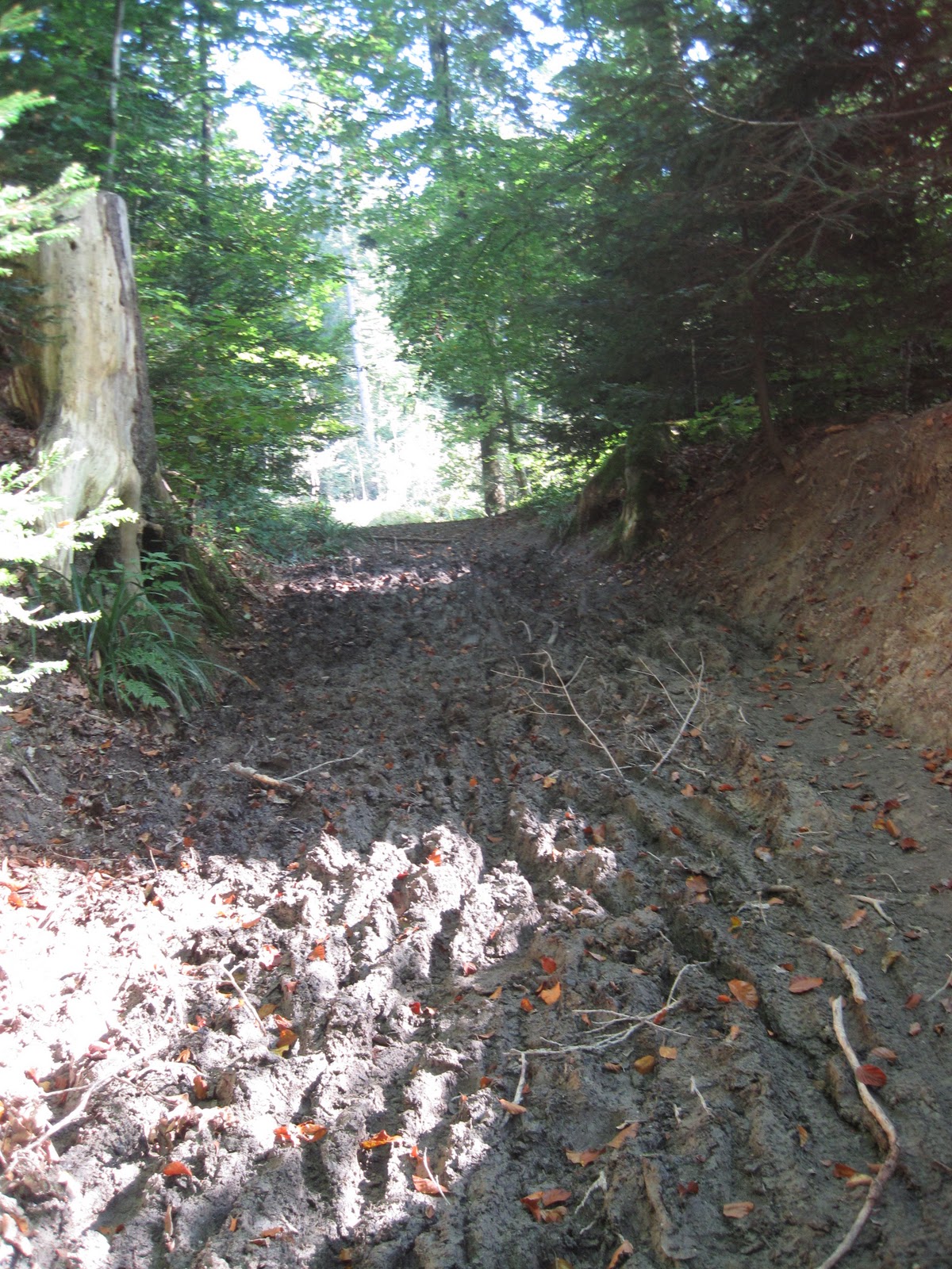
Dip down to cross the creek at the stream-aligned logs.  They are often slippery from the terrible terrible mud section up next.  


I’ve run this route all year, no matter how dry or wet it’s been recently, this next 20 meters is always muddy, there is no good line through.  Did  I mention how terrible this section this?  Extra terrible.


The short hump past the mud section needs to be widened and often needs to be brushed. I've never, never seen or heard of a trail work party in Switzerland.  How sad :(   Here you will often find your first taste of nettles or blackberries (photo above recently brushed by city workers?  I'd love to help out y'all!).  On the small descent from the short bump you will find the trail to be of much better quality.  Note the subsequent small and circumventable mud patch, this almost seems to a be a faint and failed attempt at a rolling grade reversal. 


Next traverse up the slope slightly to the washed out crossing of the small creek (looking downstream above).  Use caution and consider holding on to an exposed tree route.  


Following this you will find two extremely entertaining tree route features, both of which will result in a one to two step change in elevation of over a meter.  


The yellow pedestrian path now joins back up from the right.  Hop over any tree trunk which may have been layed across your (better) path by previous parties.


Climb up the extremetly technical and root exposed section to the switchback.  On the way back this descent is extremely fun.  


Switchback to the left on the exposed centerline gully and find the least worst line.  


At the top switchback back up to the right (the first, not the second) avoid any overgrown Nettles and blackberry and skirt the field.  Nice view, right?  This trail forms a series of elongated figure 8's.  I prefer the wooded lower right options on the way out, since the open field view on the way back presents an enticing sight line (pictured above).  


You've come to an important junction (location #1).  I often split this in the 41 to 42 minute range.  The signed yellow pedestrian downhill to the hard right is a mediocre alternative, take it once and discard it forever.  You'll instead turn left uphill on the paved road.


Avoid the path which runs straightish across the paved road and skirts sheep pastures on either side.  It's narrow, its gulleyed, its often muddy and/or overgrown and there is both electric fence and barbed wire just waiting to eat you up in case of the slightest misstep.  It's also the most intuitive line to your next intermediate destination.  A cat couldn't walk straight on this path. 


After the short ascent on the paved path take the first driveway/spur road right to find a nice section of singletrack.  Watch for overgrown Nettle and retired mushroom pickers.   Hang a right at the end of the single track on the dirt road.  You'll come to a campsite and left turn.  If you know this part well you can avoid dancing you way through the wooden posts to take the left, followed by another left and find yourself along a nice section of singletrack often overgrown with Nettles.  In 200m hang a hard awkward right at the triangular junction, followed by another left.


This turn will take you down a dirt road.  Note the Swiss foresters attention to detail.  Not to worry, the next train you take will be on time.  Guaranteed.


If you're really good you can navigate the next hard right by avoiding both wooden stiles.  Watch for blackberries. Was it worth it?  Follow this nice section of single track down past the house with the barking dog to the next control point.  


Ahead of you past the intersection to the right is a nice bit of singletrack worth exploring in the future.  At your 11 o'clock is a greyhound nursery, 10 o'clock is a horse jumping whatever.  You'll instead take a right (4 o'clock) on the gravel road. 


After 300m take a left uphill through the wood stiles.  Confused yet?  There's 2 dozen of these gates around here, each one looks just like the other.  This section runs like an underground dungeon from the Legend of Zelda, NES version of course.  The only way to nail it is to not nail it at least a dozen times.  Good news is that there are many nice routes to taken in here.  If the previous/next mile feels a bit contrived it's because I've designed this route to maximize quality single track, not to get from point A to B, unless A is 'before running' and B  is 'trail bliss'.  In that case you're in good hands.


This section of single track is a gem.  Long sightlines of slightly swervy singletrack.  Trail bliss.


Take a right when your bliss finally ends and meet gravel double track.  Hang a left when this gravel road T's into another.  You should see a yellow pedestrian sign pointing every which way except the way you came.


In 1 km you will reach a fountain.  There are often beers cooling in it.  This is your turnaround point so take a split.  Fill up if you've single baby bottled and hang a right.  Stay on the road side of the railing since the inside is a mud trap.  


Follow the first dirt road that forks off to the right and be patient.  You'll dip.  You'll swerve.  You'll pass a few promising looking intersections on either side.  Woe be tide the runner who loses patience here and opts for any of them.  Wait for pavement.  Wait for it ... 200 m or so, uphill, then take a right on a dirt road.


This is one you want.  Not the wood stiled ones 5 minutes before.  It's called Avenue de Marc, as in the French kind of Mark. 


This pleasant gravel roads dips, swerves, hesitates, then commits to a full drop and crossing of the nascent creek.  If your training partner is wearing Hoka's now is the (first) time you'll get dropped.  At the bottom feel the sand beneath your feet, listen the creek, you've just crossed the nascent Flon. 


You'll follow the Flon along a true gem of trail for the next 1.5 miles, but first head uphill for 500 m and take the obvious left to regain it along a short drop of doubletrack.   Gels.  If you've got 'em, pop em.  Strap yourself in, this is what you've come here for.  


Jump over Le Flon as double track turns to single.  The forest closes in.  Curves get swoopy and tight.  Make friends with Birches, they've been waiting for you.


You'll follow the incredibly entertaining and well worthwhile 'upper upper Le Flon' for a 1km until reaching an important 4 way junction / campsite.  Up and to the left is an OK alternative that will take you to neighborhoods and road running.  Back up to right across the Flon is a fun climb, definitely worth your time, but the recommended route is straight ahead on the left side of the creek:  lets call it 'Chutes and Ladders'.


While 'Chutes and Ladders' at time suffers from a surfeit of structures:  stairs, cribbing, and bridges, its also often the recipient of Lausanne's surplus bark chips.  It's bouncy, its squishy, it's nice.  It's one of the best trails in the area.  Watch those bridges, they can be slick any time of year.


After 1 km drop along and over (how many times?) Le Flon, you'll come across a concrete shed/pumping station.  Though the yellow pedestrian signs will suggest your path remains straight, I suggest a hard right stout climb. Slow down, this climb is a grunter, it doesn't get any easier.  You'll cross a 4 way intersection which would take you back to location #1, but instead you'll forge on, continiung the climb until you jump over the perpindicular log.  Have you got the gas to make this look good?  Thats what it's all about right?


Hang a left at the intersection with the gravel road after jumping over the log, run uphill 100 yards past the campfire/3 way inteersection and take your next left on singletrack in 100 m.  You'll now trake another left and descend sharply on paved road to find youself back at the open field.  If you've timed it right the sun is now setting/rising.  Nice view, right?


Come back the way you came, except stay up on the field instead of low in the forest off to the left.  Switchback hard back to left, fall off the rooty drop, leap over the the two stump features, cross the washed out creek.    

Pet tke kitties at the Orange House with the Bamboo and drop back over the Flon.  Down the stairs, back over Le Flon.  Get ur trail bliss on.  This section feels so nice on the way back!  Isn't it nice to be alive and running?  You're body loves you right now. 


As the trail opens back up past the Vivarium and invasive knotweed, make sure to hit the (Swiss-style) waterbars correctly.  I prefer 1 and only 1 step on the inside.  You've got 2 climbs left.


After crossing the street, you'll drop down on singletrack (2nd or 3rd time now any training partners wearing Hokas have dropped you, they'll wait up ... hopefully), and instead of ascending the first right as in the way you've descended, take the 3rd right.  The 2nd is a terrible concrete staircase which will take you back up to right somewhere between here and there that you don't really want to be.  If you had continued straight instead of taking the 3rd right on rocky double track you would soon discover what Lausanne has done to Le Flon.  Buried, forgotten, forever.  No one should ever see this.  It's not a good look.  No river should ever be buried or laid on a bed of concrete.  Lets take those dams out and live within Natures means.


Ascending this route, you'll want to stay up and to the left, dropping and crossing bridges to nowhere..  Avoid any routes leading you off to the left to a metro stop and instead take a right and quick left on single track back to the Y- shaped fork you initially reached.  Drop through the field (awesome view of La Dole sometimes) and duck under the Yew making friends with the Elm, back on (probably fresh chipped) double track.  Catch a nice view of Dent d'Oche if it's rained recently.  Second right takes you down the driveway back to Via Veneto.  Though this fountain is quite nice, there are 1 or 2 more which offers better head dunking for less hamstring stretch.  Runners are misers.


I make my way home through upper old town, past the cathedral (and many tourists)  drop down Pont (Bridge) Bessiers and come down thru L'Etoile Blanche. 


Friday nights can be hard to find the gap.  But it's all well worth it. This is my favorite route.  100 m to home.  Welcome to my world.  I really enjoy this route.  Hope you do too.