10/28/10

Reflections on the Appalachian Trail pt I: New England


The fall foliage here in Lausanne Switzerland is just about peaking.  While I've been churning over a post about running through deciduous forests in the fall for a week or two now, the poplar and maple leaves keep dropping, providing a daily refreshed soundtrack to my afternoon runs.  I've even gone out and photographed a few of my favorite local routes where the accumulation is fresh and substantial.  However, I feel like I would be remiss if I did not make a mention of the late Southbound Appalachian hike that April and I did last fall, in which we experienced an absolutely amazing East Coast foliage season from a truly unique perspective.  Southbound extends the season, and we timed our start to get the foliage peak in Southern New Hampshire.  Day after day we woke up on trail to some of the freshest rawest uncrunched leaves in the world.  Thus it was I found myself trawling through old AT photos to post here, but naturally I had to start at the beginning ... Maine, September 6 2009.  Hope you enjoy my mental photo detour!  If you'd like to read some more of our hike the trailjournal can be found here.


Why you should (never) southbound the AT in the late season pt 1/3:  New England


The first step is the hardest ... especially so if it involves summiting Katahdin.


Distance hiking is the penultimate relationship building exercise, second only to simultaneous tooth brushing.


There is this really cool mountain in Maine


Good hair days start at dawn.


Mid September is a fine time for swimming


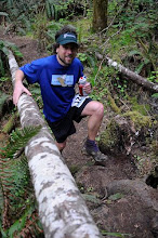
The trail through Maine is REALLY well constructed.


Pitchers plants!


The fords are more manageable this time of year ...


and if rains there's plenty of room in the tarptent,


though the mudpits are not to be trifled with.


When the sun does come back out again you might be able to experience some (gasp) dry socks.


It really doesn't rain all the time.


You never where you might run into the the Hiking Poles!  First time I met these kids was on the PCT in OR.


The hemlocks in Maine have extraordinary root systems.


Bring extra food on the second carry if the gf hogs all the food on the first.


The coffee in the 100m "wilderness" isn't half bad.


Maine has some unbelievable ridgeline routes ...


... which are particularly spectacular around sunset. 


Cooking on a homemade pop-can stove.


Viburnum's (hobblebush?) are the first to go.


If it rains so hard the the shelter wets from the bottom up, extremely large foodbags can become a flotation device ...


... and the sun comes out the next morning.


The deathtrap descent of Mahoosuc Notch.


Picking our way through Mahoosuc Notch.


The amount of work that went into this is obviously incredible, but any route that requires a mechanical engineering degree to build is at least a bit controversial.


That 1st state line is oh-so-sweet.


Quad-smashing gradients on Wildcat ridge on the way into the Whites, this trail rocks!


White Mtns ridgeline route on the AT.


Looking back on the ridgeline route of the AT thru the White Mtns


If the clouds start doing this there will probably be no fake cheese nachos waiting for you at the Mt Washington summit cafe but you may be able to work you fingers enough to zip into a sleeping bag in the rathole known as off-season Lake of Clouds dungeon (ask me about the time I begged hairtyes off April to cinch down ziplocs over my hands sometime).  Appropriate ultralight kits change rapidly in the shoulder seasons.


Frequent weather enhanced opportunities for foot care (which I actually quite enjoy).


But the companionship is great ...


 ... especially when the nights get cold.  Gf, can i borrow every single piece of clothing you have that you are not using, that sleeping bag upgrade should be at the next P.O.


Above treeline stretches on Mt Moosilauke make for happy (and cute) campers.


Meanwhile the foliage down low starts to get ridiculous ...

Ok so the lack of new material pretty clearly marks me as not having gone out for a long run for a while.  Tapering for road races is tough work!   I hope to get back to it after the Lausanne half next week and hopefully get around posting some thoughts about fall foliage, including the video of me postholing through thigh-deep Oak leaves in Central Virginia ...


10/7/10

Leysin, Berneuse, Pierre du Moelle, Roche loop


I don't normally get out for 6-7 hour runs on consecutive weekends but the Swiss high country is just so inviting and full of opportunities that I ventured out for another adventure despite some lingering hamstring unhappiness.  Even though the hamstring issue is not unexpected due to the fact that I recently started speedwork sessions again, and have not had any S-Caps to take on long runs as of late, admittedly I forced this one a bit and paid the price with some cramps and stomach issues.


Hiking is practically a national pastime in Switerland - poles, boots, and extremely large daypack required


Espresso + mountains FTW


Nonetheless it was great to spend some quality time above treeline again.  Getting above treeline, by gondola, train or by 5 lb hiking boots is so easy here it seems to be a bit of a national past time.  It's totally common to see people with hiking sticks on weekends at the train stations.  On the traverse over the pass at Pierre du Moelle I was again reminded of just how technical mountain trails here can be, not in sense of being super challenging or really cool, but more in sense of being largely unrunnable, due to either steep sections, upwards or downwards, or very rocky terrain.  Not quite my cup of tea but other options exist and it is what it is.  I'll leave it as 'not worse or better just different' for now and save the detailed comparison of Swiss trails vs American trails for a later date after I have explored more of the low country, where naturally there are many trails as well, this being Switzerland and all.


I should have stayed low on road, but instead opted for the trail up to the left


Slightly technical terrain on the 'Chemin de Montagne'


Granite postholing is bad


Mont de Ori straight ahead, the pass I'm heading (Pierre du Moelle)  for in between


Ridiculous rocky switchbacks, the trail snakes away down to the left in this photo


The area from which I just came


Random non sequiturs regarding this run:

1) Its often hard to frame pictures in this section of the Alps.  While almost everything in Switzerland seems small, the mountains are decidedly not.  How do you put a 300 ft wall in a picture properly?


The double track is generally of really high quality


The ridge route I took marks the border of the closed military zone


2) There are restaraunts and cafes all over the mountains.  I've never had to consider the calculus of espresso shots in my route planning before.  It sufficed to say that I'll do at least 300 ft of extra elevation for some mid run caffeination.

3) Ridgeline routes above treeline are not to be missed under any circumstances.  Lack of food, water, salt or trail is not a valid excuse.


Unforested ridge routes cannot be beat.  The Rhone Valley and Lake Geneva lie 6000 ft below


More ridge running


Looking back from where I came


Runnable sections of trail on the 'Chemin de Montagnes' are actually pretty rare.

4) Between the Alps and the Rhone valley proper, the routes (notice I'm not calling them trails) often go through around or very near to pastures and houses.  Rather than passing by a series of 'No Trespassing' signs only to be greeted by a shotgun toting old man, its more common to encounter an elderly couple drinking wine on their patio who are only too happy to point the way towards town, even when it runs directly by their house and through their fields.  My French is obviously not as good as I think it is because when I say to these people "Ou est le gare de Roche?"  I'm not really saying "How do I get to the train station" so much as I'm implying "I ran out of food, water and salt hours ago and am a looooong way from anywhere that will accept these Francs in my pocket for any of the above.  By the way what are you eating?  It looks quite tasty".

5) The descents from the Alps down to Lac Leman (Lake Geneva) are out-of-this-world insane.  6000 ft in 8 miles.  Seriously?  Some of the worst descents on the AT in Maine were like 1000 feet per mile, but only for a mile or two at a time.  By comparison a few of the more commonly known (to PNW ultra-runners) descents rate in as follows:

Vaud Alps summit to Rhone Valley/Lake Geneva  (6000 ft in 8 miles)
Columbia River Gorge - Dog Mtn                         (2800 in 3)
Columbia River Gorge - Mt Defiance                    (4900 in 5.6)
Mt Hood summit to Timberline lodge                     (5300 in 4)
Mary's Peak North Ridge trail                               (2320 in 3.8)
Maiden Peak to Williamette Pass ala WW 100km (3000 in 12)
South Sister summit to Devils Lake trailhead          (5000 in 6.2)
WS 100m – Last Chance-ish to 1st canyon Creek (1400 in 1.0)
WS 100m – Devils Thumb-ish to El Dorado Creek(4000 in 4.3)
WS 100m – Descent to Volcano Creek                 (1000 in 1.4)

6) Some of the more obscure towns have train stations at which trains don't often stop.  This is an example of information which is always better to know before the end of a 33 mile run.


On the descent to Roche


Water fountain and head dunking in Roche, looking back towards the gap the I headed down.


Handdrawn route map