11/20/11

JJ 100 (km) race report


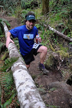
Somehow I managed to muddle my way through the Javelina 100 (km) race last weekend despite an almost complete lack of training.  The course, the volunteers and the organization were amazing at this event.  It was really a spectacle.  Camping the night before at the start line, we were awakened numerous times the calls of coyotes.  I was really excited to spend the entire day in the desert.

After 1/2 hour of running in the dark, the sunrise did not dissapoint.  The scenery was amazing in the morning light and somehow my shins were not hurting.  As an aside, if I ran this race again I would not carry a headlamp to begin with, if it's not cloudy out there will be plenty of moonlight.  I felt good on the first lap, the rocky section up was fun, the rollers even more fun, and I managed a good constant tempo back down the slightly boring double track no the way back in.  On lap 2 I saw a giant tarantula on the dirt road and struck up a number of interesting conversations which made the time go by quickly.  Starting lap three I felt absolutely great, I was excited by my 'time bank', always a dangerous notion, but I quickly began to  fatigue, in my hip flexors especially.  As the lap wore on my overall run/walk balance listed dangerously towards the latter.  I muddled my way through a good chunk of lap 4 before sunset.  I never ran another step after it got dark.  Ugh.  I get so tired after sunset, I am not sure why, but the same thing happened to me at Western States last year when I zombie-walked my way down all of Cal St.  No matter, I finished  my first 100m that day because that is what I set out to do, and I was in good shape to do.  I did not feel like walking the last 50 mi this race, so I called it quits after the 5th lap.  For me there was no point to walking in the 100 mi, when I was perfectly happy to have finished the 100km.  

It was fun, it was a great race and (before the sun set) I enjoyed myself thoroughly.  Since its raining cats and dogs here in Bloomington IN today, I put together a few plots illustrating my day.  Many people took the 100km option, probably half of all drops occurred here.  Darkness and the onset of rain were probably important factors. 


Fig 1:  Attrition rate vs lap number.  Each lap is 15 mi, except the 7th, which is 10 mi.  Attrition rate is defined by percentage of people finishing each lap (click to enlarge).


Fig 2:  Cumulative time at 100km binned by time.  All runners are considered, whether they ran 100km or 100m.  I ran a 14:28, putting me right in the middle of pack (full results here).  The 14:28 is a 1 hr PR over my only other 100km time at Waldo 2010.

I got much slower with every lap, presumably due to my poor training.  Why was my training poor?  Shin splints.  I battled with them for about 2 months this spring, but they went away and I was feeling great for months all summer, including when I signed up for race.  Then they came back, with a vengeance.  I ran ~25 miles per week for about 2 months before the race, except for the week I ran around Mt St Helens.  It just wasn't enough.  Alternatively, my tapering was fantastic, and my shins did not hurt all race.  The long and the short of it is a prescribed 1 month off of running.  I'm at the 1 week mark right now, its not so bad, not so great either, but I am keeping busy with yoga, lifting, swimming, spin class and road cycling.  It's a great way to see the country side and I might have to finally do a century ride next summer.   


Fig 3:  My lap time vs lap number.  Lap 5 = zombie walk  (click to enlarge)


Race-wise, I'm not sure if I'll be doing a 100 miler next year.  I've considered Burning River in late July, but I really enjoy the 50 mi distance.  It's easily my favorite.  I'm mulling all this about in my head as I ponder what 2012 will be like.  What I do know, is that 2010 was a great season of running because of the successful buildup to WS100.  I was strong and consistent all Spring, and I toed the line at WS in the best health I've ever been.  Ideally my 2012 season will consist of the same, with the emphasis on consistency and injury free running, even if my mileage is a bit reduced.  I'd like to experience that 'best shape I've ever been in' feeling again, and that's why I'm taking a month off to heal this nagging injury.  Internet running and 2012 planning will have to suffice for a bit.   


11/5/11

Jogging in the Jura: an overview

Jogging in the Jura:  An overview

Summary
Easily accesible from the major cities on the Western Swiss Plateau, Geneva, Yverdon, Neuchatel and Biel/Bienne, the Jura mountains form a natural border between Switzerland and France.  I spent the last year living in Lausanne, and over the course of 6 months or so managed to run the southern half (or 2/3) of Jura mountain range in Switzerland considerably.  If you are looking for information on a distance hike or run in this area I hope you might find this post useful.  My intention is to give you some good quick ideas about quality distance routes in the Jura:  which features are really nice, and which parts are forgettable.  
 
I’ve organized this post as follows:  a short summary (and link to) of specific routes, from South to North, with recommendations for shorter hikes or longer distance connections where appropriate.  I’ve also made notes about nice climbs, routes which traverse the crest,  and routes I haven’t done but would add next.  The route information given below and in linked posts is skewed towards getting to/from trailheads from Lausanne via the train, but people with cars and those who live or vacation in Geneva, Nyon, Yverdon-les-Bains and Neuchatel will also find useful information here.

When to go
The best time to head to Jura crest is just after the snow melts and just before the cows go up.  In 2011 this was April/May.  The weather on the crest can be downright nasty in winter (La Brevine currently holds the record for coldest temperature in CH).  Don't go up in January unless you are particulary desperate. The smell and ubiquity of the cows can be even nastier.  Think crocus.  If you see crocus out in numbers on the crest it’s the right time.  
  
Additional resources
You can print maps from here.  Make sure to check the sections and local trail tab.  Train schedules here.  In terms of additional equipment … It’s Switzerland, you’ll never be more than 10 minutes away from a barn, house or restaurant, and all the trails are really well signed. 


An overview of the routes described below (click to enlarge)  


An overview of the routes described below (click to enlarge)

Specific sections:  South to North

La Dole from St Cergue (post)
La Dole is a worthy day trip from Geneva, and St Cergue always seems to have a nice happy vibe to it.  The radar ball on top and shear rock face near the summit of La Dole make it easy to spot even from Lausanne.  There is a very nice unforested section near the top, but the route to/from St Cergue is characterized by cow pastures and roads.  It’s lacking in quality single track, but the climb up from La Rippe near the CH/FR border is not.  I would do that again.  Be sure to take in the amazing rock fences just to the south of the summit of La Dole.  I never did get a chance to head south from here.  It looks mostly unforested, and I believe Crete de la Niege is the highest peak in the Jura.  The only problem is that it most likely has to be done as an out and back, since navigating public transportation across the CH/FR border would be a hassle.
  
St Cergue, Col de Marchairuz, Crete de la Nueve, Mont de Biere, Mt Tendre (post)
Mt Tendre is a really nice destination from the Col de Marchairuz.  Actually, in between the two, the Monts de Biere area is one of my favorite places in the Jura, make sure to summit these minor peaks on your way to or from Mt Tendre.  The Southern half of this route, from St Cergue to Col de Marchairuz including Crete de la Neuve, is largely forested, fairly subdued, and not recommended compared to the Northern half of the route from Col de Marchairuz to Mt Tendre.  I climbed up to the crest from the Swiss plateau starting from Biere and starting from Montricher.  They were both nice, but the climb from Biere skirts a shooting range and includes more paved roads.     

Mt Tendre, Col de Mollendruz, Haut de Mollendruz, and Dent de Vaulion to Vallorbe (post)
North of Mt Tendre the Jura Crest trail returns to more dirt double track.  It’s not bad, not great, just sort of ‘meh’.  Things can get a bit confusing around the Col/Haut de Mollendruz, but the climb up the Dent de Vaulion (from Le Pont area) is a true Jura classic.  It’s mostly unforested and the views of Lac de Joux are unparalleled.  
  
Dent de Vaulion and Mont d’Or from Vallorbe (post)
In contrast to the Southern approach from Le Pont, the northern approach to the summit of Dent de Vaulion from Vallorbe is controversial at best.  The lower half is a maze of logging roads, and on the single track quality on the upper half of the climb is poor.  It’s mostly forested and sometimes feels like game trails, despite the ubiquitous blazes and rocks and trees.  The climb up Mont d’Or from Vallorbe also suffers from a surfeit of paved roads on the lower half, but gradually opens up to pasture near the summit.   Near the top is a metal can painted with Swiss colors on one side and French colors on the other.  How cool is it to cross this border on foot?

Vallorbe to Le Suchet, Mont de Baulmes, Ste Croixe and Le Chasseron (post)
The approach of Le Suchet from Vallorbe is long, boring and mostly paved.  If I wasn’t out the connect all my footsteps I wouldn’t have done this, and having done it wouldn’t do it again.  Vallorbe is a really quick train ride from Lausanne though.  Anyways the summit of Le Suchet is nice, and the area around Mont de Baulmes into Ste Croixe is one of the nicest parts of the Jura Crest.  I’ve gone up Mont de Baulmes on the Aigulles ridge itself (just OK, not actual singletrack so much as a suggested unconstructed route) and on the high quality singletrack which climbs up and over the ridge halfway down.  Take the latter, from there there are multiple ways to drop into Sainte-Croix, all of which are pretty nice.  Sainte-Croixe also has a nice atmosphere to it.  I like it there.

The climb North up Le Chasseron from Sainte-Croix is a classic.  There is a huge section of this trail which is unforested on the ridge.  You’ll love it.
  
Mt Aubert area (post
While the first few miles North of Le Chasseron are largely unforested and make for nice running, north of this the Crest dips down and the becomes a jumble of paved and dirt roads with no clear direction.  It’s really easy to get lost around the Mt Aubert area, and not a particularly nice area to be lost in.

Creux de Van to Neuchatel (post)
The switchbacks up to Creux de Van from Noirague are worth your time.  Nicely constructed, well used, and seemingly maintained, there is good reason this climb is so popular.  The Jura crest in this area is incredibly scenic.  Go there.  

I never did make it up to Le Chasseral, Tete de Ran or Mt Racine, but these would have been my next destinations, had I not returned to the US.  Surely I've missed quite a few local routes.  If you have suggestions regarding this area please leave them below.
 

11/2/11

Mt St Helens circumnavigation / Loowit Trail

There are giant volcanoes in the Pacific Northwest.  You can run around them.  Since Volcanorunning has a pretty good writeup of the logisitics and I'm feeling lazy, I'll let the pictures do the talking.

Mt St Helens circumnavigation on the Loowit trail - 10/15/2011.  Garmin says ~31 miles, but it runs a lot slower.  I think we (me an my wife April,  Frank and Ken were a bit faster) managed about 11 hrs.  It's a fantastic run, very accessible from PDX for out of town runners as well.  This one was awesome!


Frank and Ken navigate the lava rocks at dawn.  We started at 6 am with an hour climb through the forest by headlamp. 


A new day dawns in the WA Cascades


The first part of the trail (clockwise circumnavigation on the Loowit trail) alternated between islands of firs and large coarse lava rocks


Is Mt St Helens still on the right?  Then you are not lost.


April, Frank, and Ken navigate the lava fields.


Climbing out of the Toutle River valley was one of the highlights


Toutle River valley


This years fresh crop of Douglas Fir cones on the branch.  Really makes me miss the fresh hop beers of the PNW


April climbs up out of the Toutle Valley


The money shot.  Mt St Helens from the North.  The 1980 eruption came down this way.  Here is a nice aerial view.


April in the blast zone


Up and over Windy ridge and off the Plains of Abraham


April smells the barn


Yep.  You can run around Adams too.


The last portion of the route (4 to 5 o'clock) goes up and down a series of deep lava valleys.


More Adams


Aid Station on the way back in.