3/27/10

Chuckanut 50km race report


            Race morning arrived on one of the nicest days of the year.  The Chuckanut 50km starts out and comes back along the 6 mile flat Interurban trail.  I ran slow and relaxed and made sure my breathing was easier than the folks around me.
After a few miles on the Interurban trail we turned up on singletrack into some proper climbing.  I worked on my power walking and enjoyed the great trail around Fragrance Lake and many a Skunk Cabbage in bloom alongside the trail.  I followed my usual race strategy of not passing anyone until after AS #2.  At this point the trail began a long climb on a road and I got a chance to put all those Wednesday night powerhikes up McCollough to the test.  I was pleasantly surprised to hike past many people who were working much harder than I to run up the hill.  This was the first 50km that I have worn my heart rate monitor and was able to find myself a good groove:  running the hills until I hit 165 bpm, and then hiking and trying to keep my heart rate above 160 bpm. 
            Finally we made the turn onto Ridge Trail.  This trail is amazingly fun.  It’s very technical and I passed a lot of people here.  After the ridge trail the course came back on a long straight flat and gradual climb back towards AS #4.  This section went on for longer than many expected.  Quite a few people had run out of water and I saw one guy filling up from the creek.  By the time I arrived at AS #4 I was so hungry that I barely realized it was April’s mom that was handing me food.  Thanks for the help Mary and the rest of the volunteers!


The course according the Garmin, note the long out and back in lower left, and Ridge trail on top

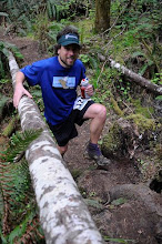
            The final climb up Chinscraper awaited.  I knew what to expect since our friend Heather had taken me up this one a few months before.  It was quite a grunt.  Despite the near heart attack, I wasn’t able to shake the guy just behind.  He was like the new Terminator in T2.  I barely managed to hold him off by the time we hit the top.  After AS #2 I passed about 50 people or so and was never passed. 


Are you John Connor?  Then I must pass you on Chinscraper trail!

            After a bruising descent, presumably good downhill training for Western States, we turned back onto the flat Interurban trail for the stretch back into Fairhaven Park and the finish line.  I ran the ‘back’ on this section about 40 sec/mile slower than on the way ‘out’.  This is a reduction of speed by 7.5%, which I’m pretty satisfied with.  I could have done a better job keeping my heart rate down on a few of the small technical climbs on Ridge Trail.  They add up.  I think I can also get a bit faster powerhiking up hills.  All in all it was a great first race of year!

3/17/10

MaptheMaze


There are some trails you have never taken, and there are some trails you should never take.  A little of both can be found on the Starker Forest Land adjacent to the Macdonald Forest.  In the area known as The Maze you’ll find tangles of trails, sometimes technical and sometimes steep, water features that make you wish you were wearing Crocs, and climbs that make you wish you had opted for couch-fridge repeats instead.  The thing about this section of forest is that’s its special.  It’s the only forest I’ve ever ran in that consistently decides when and where I get out.  It always pays to bring a little extra food and water in here just in case you get a bit turned around.


Two runs worth of mapping the Maze.  Dimple is on the upper left, Sulfur Springs bottom center.


On the climb up Who do you love.

I learned this lesson well a few years ago on one particular run in the Maze.  Despite the clouds and lack of sun, I felt like I knew where I was.  The junction I got to was in the right place, but the intersecting creek was running the exact opposite direction I had expected it to.  Sufficed to say that I did get out of the Maze that day at either the time or place that I had intended.  I feel strongly that no one can really say they know the Maze until they have run out of both food and water simply trying to escape from it … multiple times.


This is a valid exit ...  Baker Creek Trail.

Despite spending an entire graduate degree’s worth of Saturdays exploring these trails, its still pretty tough for me navigate.  For someone with little experience in this area the available maps are at best little help and at worst downright misleading.  The map available on the Macdonald forest run website (the course goes thru the Maze for about 8 miles) is somewhat useful.  


Delphiniums coming up on Shave and a Haircut, part of the Mac course

There are intersections on the map that don’t exist in reality. There are intersections in reality that don’t exist on the map.  Many of the junctions that you may find don’t have the proper number of intersecting trails. 


At the bottom of Shave Cutoff.  Decisions, decisions.

Its time for a new map.  Enter MaptheMaze project.  It’s my pet project for the next few months while I’m still in Corvallis.  All known trails in this area have been mapped at least once so far, and possibly even some unknown trails.  Did you know there is a shortcut from the bottom of Bombs Away to On the Sly?  The gradient on this one is uniquely Oregon:  If it’s muddy enough on the climb you might end up going backwards.  It’s not uncommon.  I think I may have found the entrance to Poseidon's kingdom last weekend.  It’s at the bottom of a deer trail that you should NEVER take.  I’ve done it twice.  Regretted it both times.


Not sure what to call this one:  6 months of Styx or the Entrance to Poseidon's kingdom?


Parallel to and East of Shave and Haircut.  Don't take this one.  Ever.  Trust me.

I’m still working on the software issue, the best choice right now seems to be a commercial product called TopoFusion.  Really nice maps were made for the recent Orcas Island race (here) using this product.  I’m still hemming and hawing a bit over purchasing this software, but since its helpful to average multiple tracks due to Garmin watches lack of accuracy in heavily forested areas, I have plenty of excuses to go out and remap all these trails again and again.


Awesome new switchbacks on Crosscut.


3/7/10

Western States vs. Weather

Question:  What is the chance that any given starter will actually finish Western States 100 miler in June?

Answer:  66%.  A priori, those are the odds of any randomly selected starter actually finishing Western States 100m this June.  Presumably the chance of finishing might be even lower for people who are attempting their first 100 miler, such as myself.  Since fitness doesn’t accrue from training alone (it requires some good rest after) I decided to take a look at some of the historical data from the Western States website.

Finishing rate versus year.

Question:  What determines the finishing rate of the race on any give year?

Answer:  According the Western States participant guide one of the most commonly cited reasons for not finishing the race is due to the heat.  There are some strategies that one might do to mitigate this, but I’ll address those in a future post in May or so when I actually start doing them.  For now I’d like to focus on things that are totally out of my control.  It feels good.  Trust me.


High temperature in Sacramento on race day versus year.

            The finishing percentage at this race actually depends quite a bit on the weather (as an aside there has also been a fairly significant secular increase in the percentage of finishers with respect to year, thus I didn’t look at years prior to 1989 for this analysis).  The mean high temperature on race day at the Sacramento Airport, which is fairly close to Auburn and has longer and more consistent weather records than Auburn, is 89 F.  The correlation between finishing percentage and high temperature on race day is fairly high, with a slope of approximately 5% per 10F.  That is, the chance that any given runner will finish given the climatological high of 89 F is 66% (and no, despite the fact that I'm getting a PhD in Atmospheric Sciences I did not look for a secular increase in high temperature on race day with respect to race day).  If the high temperature is 10F warmer or cooler than the climatological mean high of 89 F, the odds of any runner finishing go up or down 5% from the historical average of 66%.


Correlation between finishing rate and high temperature on race day.

            There’s quite a bit of scatter in the data, but the finishing rate from the last few years generally follow the trend.  2006 and 2009 were hot and had a low completion rate, while the highest completion rate as of late was in relatively cool 2005. 


Finishing rate and high temperature for the last few years


Interestingly 2006 and 2009 show a large number of drops from Last Chance AS to Cal2/Peachstone AS, miles 42 to 70 (labeled below as aid stations #8 and #14 respectively.  Perhaps this depends quite a bit on the fact that this part of the course is tackled by many at the hottest part of the day, as well the cumulative accrued mileage, and the significant hills to dealt with.


Number of runners left versus aid station for the last few races


Elevation profile of the course from the WS website (note the profile goes from right to left)

            Now 66% might sound a little low.  Non-running friends of mine might be thinking ‘Yes Craig but you train a lot and you’re fit’ (running friends of mine might be thinking something totally different).  Well yes … but I have no reason to believe that my training over the next few months will be any better or worse than anybody else out there, except for the really fast people, but since their training is so much different than a first timers there is little use for comparison.  Naturally I’ll be running my first one to finish, not for time. 
So what does it take to run 100 miles?  I have no idea.  I’ve done a 50 miler before.  It wasn’t so bad, but I’m not sure that’s indicative of me having any sort of clue whatsoever about what I’ve signed myself up for, or how to go about training for it.  The internets have been quite useful in forming a training plan, so have the local runners, some of whom are absolute fountains of knowledge.  In retrospect this might be a classic case of ‘talking about running a 100 miler is a lot more fun/easy than actually training for and running 100 miles’.  To be fair, I didn’t expect to attempt to run a 100 m this year.  The plan was to run a 100 km and next year get into and run Western States, since the lottery system for Western States favors those who didn’t get selected the year before.  Fate intervened.  I lucked out and randomly got selected for entry.  Given that I’ve never actually failed at trying to run this distance, there is no reason to believe that I can’t do it, right?