4/27/11

Jogging in the Jura - Le Suchet and Chasseron


After finally running my early season road marathon last week I celebrated the opening of Spring/Summer mountain running season with a return to the Juras to pick up where I had left off.  After a quick train ride to Vallorbe from Lausanne I quickly found the Jura Crest trail and headed North ... and up.  The plan was to get Le Suchet and possibly Chasseron depending on how I felt.

The day progressed quite nicely, I found water when I needed it and felt great on the slopes of Le Suchet and Chasseron.  In between I found some unexpected nice sections of trail on Aigulles de Baulmes, which is definetely worthy of a return trip.  After Chasseron I decided to press on and drop off the Jura Crest a few miles up to the East towards one of the cute villages along Lac Neuchatel.  This would greatly facilitate the next leg of the Jura Crest to the North for a proportionately smaller effort today.  While this seemed like a good idea at the time shortly thereafter I blew up.  I dont know why but I really struggled the last few miles in.  I expected a quick efficient descent and instead found a long ago abandonded, unsigned and hidden trail overgrown with fresh Nettles.  I assumed that a reroute would be found a few hundred meters up the trail but instead ended up traversing miles over to the next trail off the crest.  Have you ever found yourself coming around a slight bend on a dirt road only to see the road climb when you know it should be descending?  I was holding my map and cursing the topography.  I briefly considered and rejected bombing straight down a 50% grade through the forest and thickly brushed understory.   After finally making out of the woods I cross countried my way through a bunch of pastures and pea fields and finally laid up at the water fountain in Champagne waiting for the post bus.  Whew!  Those last few miles the wheels really came off.


The Swiss cows were definitely enjoying being let out of the barn

After passing out of Vallorbe the route went through the very pleasant village of Balluiges


Fields of dandelions on the slopes of Le Suchet.  Dent de Vaulion in the background


Climbing up Le Suchet


Solar panels out in the middle of the Juras


Remnants of WW II tank defenses in the Jura.  The Toblerone Line.


On the Southern slopes of Le Suchet


Looking South at a previous weekends work:  Dent de Vaulion in the middle, Mont d'Or is the rocky ridge to the right, Mt Tendre off to the left.


Summit of Le Suchet 1 km off


Aigulles de Baulmes from Le Suchet, the trail I took went up and over this ridgeline, it was a very nice climb ...


... but the upper portion of the descent of Le Suchet left a bit to be desired


While the lower portion of trail to the NW of Le Suchet was superb!


Climing up towards Mont de Baulmes


On Mont de Baulmes and heading towards Ste Croixe


Sainte Croixe off in the distance


Really nice descent of Mont de Baulmes


Gentians on the slope of Chasseron


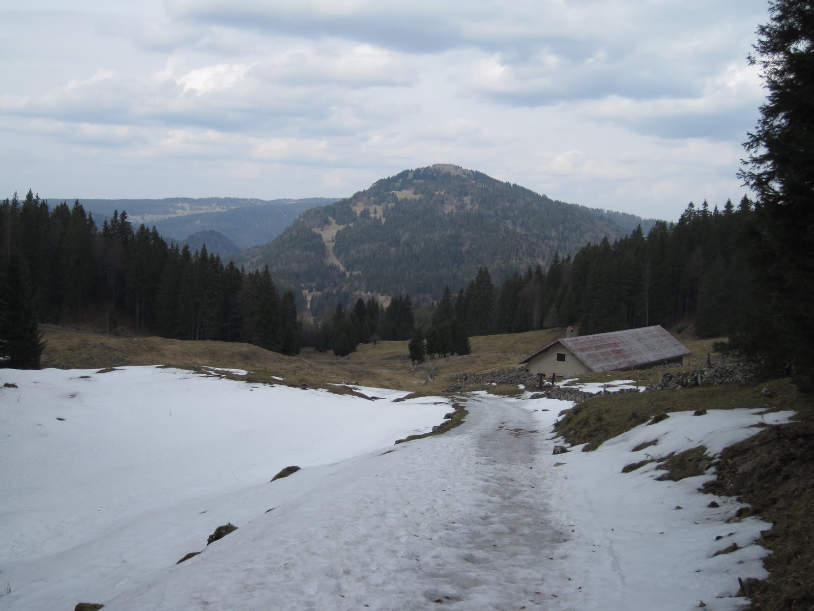
On the summit ridgeline of Chasseron.  Mt Aubert and Lac Neuchatel off to the right


The northern descent off Chasseron


While descending off the Jura Crest I ran into ...


... a really nice orchid and ...


an adorable little Gallium.


Garmin says - 26.8 miles with 6300 ft of vertical.  Latest effort in pink, this map shows the southern 1/3 of the  Jura mountains from Lake Neuchatel (bottom) towards Lake Geneva (upper left)

4/23/11

Zurich marathon race report


I had a very nice time at the Zurich marathon last weekend.  I lined up right around the 3:30 pace group and immediately noticed everyone else looked much skinnier and faster.  Nevermind, I managed to set a nice pace and hold on to it pretty well, thus splitting the difference between my A goal and B goal with 3:27 for a 9 min PR.  I ran the 2nd half 3 min slower than first, or about 15 seconds per mile slower.  I’m happy I went out just tad too fast so at least I know where I stand fitness-wise.  This was my 3rd road marathon, but the first the first that I really trained for, and the first where I ran for time.  I think I can bring my time down a bit more, I’d love to qualify for Boston soon, but I think it will take a few years at least.

Afterwards I did some research to see where my training pace lined up.  The recent 5k and ½ marathon I did predicted my marathon time within few minutes, but my intervals were much too fast.  No wonder I was  dreading the track workouts.  I was also doing my long runs too fast by 20-30 seconds or so, which is probably why I wasn’t able to get a 2nd quality session in during the weekdays.  Next time I will ease of the pace on quality days and try to add more tempo workouts between 3-13 miles, which totally took a backseat to long runs and track days for me the last few months.  I will also train at a much more reasonable but still optimistic pace, since now I know it will be at least a few more until (or if I ever) I get my BQ.  Now that road season is over, I am really looking forward to getting some vertical into my diet.  Bye bye roads, hello mountains.

4/12/11

Moleson and Me


Due to its prominence and size, the summit of Moleson has intrigued me from the first time I laid eyes on it Fall of last year.  Accompanied by hikers, I was at the time in no position to attempt a summit, and so I vowed to return as soon as possible to tackle it.  Nature intervened.  A mid December attempt proved fruitless (and obviously mistimed) due to the snow, but was very successful if success is measured by amount of chocolate or cheese ingested.  An early season heat wave all last week melted enough snow that I opted for another shot the 2002 m peak, rather than a return to the crest of the Swiss Jura mountains (~1500m) where I had spent a good chunk of April's weekends. 

I love going to bed on Friday nights thinking about tomorrows climb. This one proved to be quite tough.   4150 vertical feet in 7.3 miles, which was about 1.5 miles and 1/2 hr longer than I had hoped.  The day warmed up quickly and at ~75 F it was easily one of the warmest days of the year.  The snow conditions were fine, but much of the Western ascent route was on cow pasture.  I opted for a few shortcuts here and there and did about 1000 vertical feet at 45% grade.  Ouch.


Approaching Moleson from Gruyere area


There were only a few snow fields to cross, this one had a terrible run-out so I went around and straight up through the cow pasture ...


... where I was rewarded with some great wildflower sightings.  I'd guess this might be a Synthiris (Snow Queen)


and this is the bluest Gentian I've ever seen.


From Moleson I took the ridgeline route South towards Teyschaux


and then dropped off the ridgeline route to the right after the fields of crocus, which were absolutely peaking


Snow-wise this run was done with perfect timing, here the very side of the road is open for running


Crocus for days on the descent of Moleson


Daphne in bloom and very fragrant


The SW route off the Moleson Teyschaux ridge had some very nice runnable sections


Beginning the ascent of Nirenmont to the West


On the very pleasant and well worthwhile peak of Nirenmont looking back at Moleson on the left.  The pasture I climbed is slightly below and to the left of the summit


Garmin says - 19 miles with 5600 ft of vertical est. (Garmin died on the way up Niremont). About 1/4 of the ascent of Moleson was at 40-45% grade.

4/10/11

Jogging in the Jura - Mt Tendre and Dent de Vaulion

With spring coming along quite quickly on the Swiss Plateau I made another trip out to the Crest of the Jura mountains to check on the snowpack and wildflower progression. This run started in Biere, and in typical Swiss fashion, proceeded directly alongside a shooting range. By the end of the day I summited Mont de Biere (highly recommened), Mt Tendre, and Dent de Vaulion and finally got a look at the Lac de Joux.


Garmin says: 25 mi w/ 5000 ft of vertical.  Sundays effort in Orange.  The route started in Biere, climbed up to Mont de Biere, Mt Tendre, traversed over to Col del Mollendruz and Haut de Mollendruz.  Garmin died on Dent de Vaulion, but I had that track from a previous effort.  The photos shows tracks from 4 runs.  I hope to connect footsteps over as much of the Jura Crest as possible.


Good thing I know what 'zone de tir' is.


Daphne in bloom. Its quite similar to the cultivated ornamental type we grow in the US. Equally fragrant, but with deep purple flowers.


Euphorbia near 700 m


Petasites growing along the roadside, very similar to way it does in Western US


On the climb up Monts de Biere from Biere


Crocus just beginning along the Jura Crest


Rotten snowfields


On the summit of Mt Tendre


Looking North along the Jura Crest from Mt Tendre, from middle to left: Haut de Mollendruz, Dent de Vaulion and Mont d'Or (in France)


Postholing through rotten snow was the name of the game today


Icy back roads


Beautiful back roads


Stone wall near Col de Mollendruz


Nearing Dent de Vaulion, note the switchbacks


I have no idea what this is: Food storage, old military supply bunker?


Beginning the wonderful ascent up the Southern face of Dent de Vaulion


Looking back down Dent de Vaulion towards Lac de Joux


Summit of Dent de Vaulion


Looking North towards Le Suchet and Chasseron.


The border town of Vallorbe was the days destination


Crossing the Orbe into town