With training for
Western States done and my PhD safely defended I decided to take a little road trip this past week to run some trails that were on my
Oregon bucket list (
link to map). Despite the large amount of time I spent in my car and going multiple days and multiple runs without a shower, I saw some pretty incredible places. The itinerary in NW Oregon and the Columbia River Gorge consisted of the following trails: Saddle Mtn near
Seaside,
Ecola Beach to Indian Head, Ft Stevens at the head of the
Columbia River, Hoyt Arboretum in
SW Portland, and in the Columbia River Gorge, Dog Mtn and Mt Defiance. Warning: massive amounts of photos below.
1) Saddle Mountain
The trail up Saddle Mtn begins innocuously enough, gently climbing through Firs and Western Hemlocks past monkeyflowers and Cow parsnip till shallower and rockier soils where the forest thins out. There the trail construction became vulgar: chain link fence strapped over the tread to keep smaller rocks from sliding down the trail. Perhaps this is due to the trail being so steep and seeing a lot of use. The views about treeline here are virtually unparalleled in the Oregon Coast Range (except perhaps outside of Mary's Peak). I pushed hard up the climb and failed coronary attempt aside, this is one trail well worth doing.
Monkey flowers on the ascent
Something in the Saxifragaceae
Gently climbing trail on the initial ascent
Oddly constructed sloping bridge
Chain link over rocks
Minor drainage issue: trail = creek.
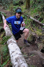
The saddle of Saddle Mtn. Wow!
Summit shot of the author. Coronary attempt # 3 failed.
On the descent from the summit.
What was the largest Sitka Spruce in the world until a few years ago.
2) Ecola Beach
Next up was a run at
Ecola Beach state park (
link). The night before I slept at some lean-tos between Indian Head and
Seaside. I highly recommend checking these out and I would have taken some pictures but it was poring buckets the whole time I was there. The rain continued the next day for my entire run and the trail was not all that impressive. Perhaps due to low population density and high use (i.e. residents vs. tourists), many of the trails on the OR coast suffer from poor maintenance. A few drain dips here and there would do wonders to help this one. You might recall from 2nd college math that some infinities can be proven to be larger than others. I'm pretty sure the mud pits on this trail could actually consume black holes in addition to size 12EE shoes. The fact that I took the road back to my car instead of the trail says everything about this one that needs to be said.
3) Ft Stevens
The short hike along the Jetty and spit in Ft Stevens State Park (
link) was very nice. Its only one or two miles long, but I've always wanted to see where the
Columbia river goes out to sea.
Shipwreck near Ft Stevens
Hike around Ft Stevens head. On the left the Columbia Rives is meeting the ocean.
4) Hoyt Arboretum
Unfortunately the torrential rain continued for my jaunt through Hoyt Arboretum near Portland the next day. I found the Monkey Puzzle tree I was looking for but had some navigation issues and ending doing a few bonus miles of the 'out of food and out of water in a terrible rainstorm a long way from the car' type. Nevertheless the trail in and around Forest Park is fantastic and I was quite impressed with the collection at Hoyt arboretum.
5) Dog Mtn
Of the many fabulous trails in the Columbia River Gorge, the ascent of Dog Mountain is an absolute classic. Boasting 3000 ft of elevation gain in 3 miles, this one of the steepest sustained climbs in the PNW. I resolved to run every step and got massive trail props on the way up. Among the comments passed along to me by hikers on the trail: 'You're intimidating' and 'you're amazing'. Ok thanks, its nice to know I can run every step of this climb, but when I reached the summit running and huffing and puffing, it felt a bit uncomfortable to be stared at by the dozen or so hikers having a snack and taking in the view. Ok yes I might be half naked while everyone else is in rainjackets to protect from the biting wind but I'm mostly like the rest of the hikers out there, I just so happen to enjoy a different pace. Faster or slower is not better or worse, just different. It was nice to see so many people out on the trail enjoying Mother Nature and the unforested slopes of this Mountain are an absolute must for wild flow enthusiasts and view seekers alike.

The trail up Dog mountain
Balsam root on Dog Mtn
6) Mt Defiance / Starvation Ridge
The defining characteristic of Gorge trails can be summarized succinctly: steep. The hike up Mt Defiance, roughly 5000+ ft of vertical in 5 miles is no exception. Other than the gradients the trail is well constructed. Towards the top it becomes very rocky and large portions are unrunnable, unless you want your knee to look as below ...
Sedums on the trail up Mt Defiance
The climb up Mt Defiance is steep
The climb up Mt Defiance is steep
Mt Defiance trail
Switchbacks up Mt Defiance
View of Adams from the Mt Defiance trail
Rock meets knee. Blood ensues.
4000 ft of vertical away from car. My knee doesnt normally have the knob thingy
Not good. The view at the summit of Mt Hood was really nice, but the trail is virtually all forested. I had a minor navigational issue on the descent, but was aided food-wise and water-wise by separate hikers. Thank you! Poor form on me. The descent was not the glamourfest that I had anticipated due to the shape that my knee was in, but all in all this is a very fun and challenging trail. If you ever decide to tackle this one I recommend the following: take two times as much food and water as you think you might need.
Summit shot at Mt Defiance, Mt Hood in background
Anemones on Starvation Ridge descent
Descent of Starvation Ridge: Mt Adams in background
Scree slope on the descent
Sharp descent on Starvation Ridge
View of the Columbia River Gorge
400 calories was definitely not enough. I should have heeded the namesake.