A few days after a really nice run following the Montreux to Rocher de Naye course last weekend a bit of snow fell in the Swiss Alps. Desperately I wondered if the high country season could be coming to an end already, and vowed to get out and get some anyways. If it truly was the end of the season I wanted first hand proof, and was not going to go down without a fight. Despite my complete and total utter lack of French speaking ability I finally managed to track down a book store in Lausanne
Climbing through the vineyards of Villenueve
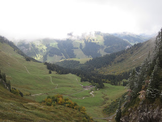
I had thought the cloud layer would lift a bit, but it never did.
Very shady route to ridge, this is near where I turned back for the lower route to the pass.
The ridge I was attempting to acheive, Col de Jaman on the left.
The combination of snow that fell on the high country this week and the preponderance of onerous looking low level clouds meant that I would spend a full 5 hours without seeing another soul today, something that I don't think is common the Alps at all. The route on which I attempted to gain the ridgeline teetered between terrible and downright nasty. After 2hr 40 min of sustained unbroken ascent starting from Villenueve on Lake Geneva , I finally turned back not far from the ridgeline but obviously 5 minutes after I should have. In the pantheon of technicality this trail rated 'buttslide hand over foot on the way down' status. It was shady and there was more exposure than I prefer. Going down it was no quicker than going up, and decidely less safe. Once descended back to last junction, I contoured over to gain the Col de Jaman via the lower route and then turned up towards Rochers de Naye.
Signs at the Col de Jaman. Ideas for future runs in here somewhere ...
The Valley to the North that I might try to approach from next time.
The trail on this section was routed on the ridgeline and was quite impressive. About 6 inches of snow lay on the ground and more was falling. Despite low visibility to the West I grabbed a quick espresso and malted chocolate malt balls at the gift shop, warmed up, recharged and headed back out in the snow and fog as significantly more intelligent tourists and families simultaneously packed into the furnicular train for a much warmer and quicker descent back to the exact spot I was heading, Montreux: the Venice beach of Switzerland.
Ridge route near Rochers de Naye
Ridge route near Rochers de Naye
The Rochers de Naye restaurant in sight
Numbers do not lie
Breaking for a quick pick me up before the descent down to Montreux
After 6 hours of running this descent is truly a monster: 5200 ft in 9 miles. However I found a nice propioceptive balance and hit my footwork well and kept the wheels turning towards food, warmth and home. The 80 minutes descent, of which only about 10 minutes is so steep that it's unrunnable, felt quite nice. Nevermind the snow, what a great run!
On the descent to Montreux
On the descent to Montreux, Lake Geneva in the background
About 40 minutes into the descent from the Rochers de Naye summit
This farmers was moving his cows over one field while I was on my way down
A handdrawn route map


No comments:
Post a Comment