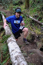
My one and only shot of the day about 2/3 of the way up the initial 5400 ft climb into the Vaud Alps
Since I've moved to Switzerland
Ok that might not be the literal translation of 'san issue' but it's the one forever etched into my mind. A little context might serve. On my second weekend in Lausanne , Switzerland
Gasping for breath alongside hordes of tourists who walked 50m to the summit, I gazed off into a seemingly interminable jumble of glaciers, meadows, valleys and forests: unimaginable adventure and places to explore. The mountains beckoned me to stay for a few hours more and from my windswept and sunkissed vantage point I could see a pretty good route into the next valley or maybe even the one thereafter. Already I had spent and hour above treeline, something I hadn't quite expected and plus there was an espresso machine in the train station 10 minutes down from the summit. What I hadn't counted on was that 'next valley over' in the Vaud Alps pretty much guarantees a descent/ascent of at least 2000 ft. I also hadn't realized from my vantage point that I'd have to / want to summit the Dent de Jaman as well (note: the below pictures I just grabbed from the web since my camera batter died). After summiting the Dent de Jaman I made my way down the Col de Jaman (the pass down and to the right of the above picture) and that's where I had a few slight translation/navigational issues on the descent through fields and small Swiss hillside villages on the way back to Montreux.
The Dent du Jaman from Rochers-de-Naye. Parts of the climb were hand over foot. Furnicular train is on the left.
I really enjoyed my first venture into the Vaud Alps, especially since so many options seemed available for future runs. Sunday's run by the numbers.
Route: Montreux to Rochers de Naye and loop to Dent de Jaman, Col de Jaman, initally following the race course (http://www.montreuxlesrochersdenaye.ch/Default.aspx), the map of which I definetely left at home
Distance: 45 km
Cumulative Elevation gain: 7000 ft
Time spent hand over foot or clinging to fixed ropes: 30 min
Initial ascent: 1650 m in 18 km (5400 ft over 12 miles), slightly less than 10% grade
Final descent: about 1.5 hours, including about 20 mins of flats
The famous statue of Freddie Mercury in Montreux marked the end of my run and the beginning of a hunger I haven't felt since Waldo.


