Showing posts with label swiss bunker. Show all posts

2/15/11

Jogging in the Jura - Mt Tendre/Montricher to St Cergue

Though I still haven't managed to fully shake off the ankle/calf injury that I sustained a few weeks ago the weather was so nice I went out anyways to explore some of the Jura Crest Trail (Chemin de Cretes de Jura).  It seems that after a cold and snowy December winter is likely to end early and with more of a whimper than a bang here in Switzerland, thus I had high hopes for good trail conditions on Saturday.  Ostensibly the primary goal was to find a convenient high quality climb for hill repeat training for UTMB, but really I just wanted some good quality time to get to know the Jura mountains.


Sunrise over the Swiss Plateau from near the town of Montricher (see map at bottom)


These signs are all over the mountains in Switzerland

The climb out of Montricher to the summit of Mt Tendre, 3238 of vertical in 5.2 miles at 12% grade, was all that I had hoped for.  High quality trail, generally well constructed and maintained, and definitely a worthy place for repeats.  It wasn't until about 4500 ft or so until icy conditions began.  The snow wasn't bad, especially not in the pastures near the summit of Mt Tendre (5457 ft), but some of the forested gullies were completely iced over. My hope that this was only a function of time of day proved unwarranted, and some tricky sections had to be navigated quite slowly over the course of the day.


Half a mile south of Mt Tendre on the Jura Crest Trail (Chemin de Crete du Jura) the trail traversed an icy sidehill with a long and dangerous runout.  I opted for the bare ridgeline where there was no danger of a slide.


Looking back at Mt Tendre on the crest of the Jura mountains.  A few minutes earlier I was on the summit in a whiteout


Summertime Chalet on the crest.  Rock mover lever thing-a-ma-bob and solar panels.


Old WWII fortications on the Jura Crest near the French Swiss border

The trail along much of the crest is of good quality, especially the forested sections.  As per usual in Switzerland, the trail was often routed through summertime cow pastures.  While the views are splendid, the footing can be quite tricky.  Routes like this make make me happy I played a ton of tennis growing up, the constant side to side motion of the game led to great ankle strength.


Summit shot from the Mont de Biere


Fantastic descents heading north towards the Col de Marchairuz and Crete de la Nueve

While the snow in the pastures was fairly straightforward and not too significant, there was some really icy conditions in the forest.  I had to climb my way around much of the trail, clinging to whatever shrubbery I could along the side of the trail.


Icy gully


Towards the summit of Crete de la Nueve


Approaching St Cergue on the Chemin de Crete de Jura 


Garmin says 5600/3350 ft of vertical in 21 miles.  

All in all not bad for a early season outing in icy conditions.  Though I got a little bit rough around the edges earlier in the run than I would like to, it's only to be expected with the snow making for slow going.  It was great to be able to take advantage of the sunshine.  The route, starting in Montricher climbing up to Mt Tendre and South along the Jura Crest Trail with Mont Biere, Col de Marchairuz, Crete de la Nueve and down to St Cergue was quite fun and will make a good addition to the SFP (Swiss Footprint Project).  If someone were wishing for a shorter route I highly would recommend heading North from Cold de Marachuz to Mont Biere (Derriere) and the Ski Chalet.  This section, and the section continuing on to Mt Tendre, was quite scenic.

11/12/10

Backcountry Swiss bunker touring: The endless summer continues ...


The idea for a Chateau d'Oex to Villenueve route was seeded into my head on a recent run up to the Col de Jaman when I came upon a sign with what appeared to many ideas for another good run.  Last Sunday I woke in the predawn darkness and boarded a train to Chateau d'Oex.  It seemed likely that I'd end up back on Lake Geneva by foot later in the day.  The plan called for staying a bit lower than usual, opting for dirt roads over nonexistent trails whenever possible.  The route, from Chateau d'Oex to Villenueve, would neccessitate climbing over the Col de Sonlomont and the Col de Chaude, neither of which is a gimme in November.

The route looking South from start to finish


The route from Chateau d'Oex (right) over the Col de Sonlomont, down to Lake Hongrin, over the Col de Chaude and switchbacking down to Villenueve on Lake Geneva.

Route planning is generally fairly easy in Switzerland.  Everything is (mis) labeled.  Take a train to somewhere, get off the train and look around for one of these yellow signs.  If you are lucky there will be a tiny stand open right next door selling coffee to get you going.


Topo map and estimated hiking times outside of the Chateau d'Oex train station.

The route started flat along country back roads, the Col de Sonlomont can be seen in the middle of the picture below.


Eventually the climb started past houses, pastures and then through forests.


On the climb up Col de Sonlomont


Obligatory Swiss cow photo


Still climbing up Col de Sonlomont

After I acheived the pass I had to navigate downstream of damned lake, the valley that used to hold the creek is below to the left.  The road turned into trails, then the trails turned into cow pastures.


Above Lake Hongrin outlet, the next valley I am heading for is over to the left.


Above Hongrin Resevoir outlet, storm blowing in from left to right


The route over into the next side valley looked promising up to this point, but then it promptly died out in an abandoned-for-the-year cow pasture.  This wasn't just any cow pasture though, this was a Swiss cow pasture.  I considered my situation carefully.  The map clearly showed a route down to my left, but the facts on the ground didn't line up.  There was this impossibly steep pasture.  There were some toppled and very difficult to see barbed wire fences, and an impending storm that was already shortening my desire to study the map any longer.  I did think I saw something a while back that would get me around this mess.  I just had to get down to the road by Lake Hongrin.  I backtracked for 1/2 hour before getting really frustrated at how far back the turnoff for the low route was.  When the route opened up from forest to unforested gully, I headed straight down for the lake.  It was terrible.


The gully which invited me down to Lake Hongrin


The gully shortcut alternated from young forest caked in blowdowns to impossibly steep bushwack through rosebushes and raspberries.

After 45 minutes of bushwacking my way down this slope, about 5 minutes from finally achieving the road at Lake Hongrin I came upon what I think is an old Swiss military bunker.  It turns out that Switzerland is full of these, many of which have been turned into museums.   


I didnt find any old Swiss army knives here, but the ruins were still pretty neat.  The reason I had wanted to avoid this low route was because I had to go through a tunnel, but as it turned out there was a little sidewalk in there.  The Swiss engineers obviously consider pedestrianism in their designs.  By the time I was through this tunnel it was raining in earnest.  I looked uphill to my right about half a mile to see exactly where I had turned around 1.5 hrs earlier.  The trail which was so clearly marked on my map was nothing more than a route through a cow pasture someone had imagined might be nice and decided to mark down on the paper.  There was no trace of any trail whatsoever from either side.  Still, it did have some appeal, and was the type of thing that I'm not generally averse to, as long I have a good idea what to expect.  Or, better yet, as long as I have no expectations.  When I get lost, I prefer to own it fully.


The tunnel I was hoping to avoid


Heading towards the second pass of the day

On the climb up Col de Chaude the weather turned truly nasty.  I took out my rain jacket, stuffed some food into the internal fire and picked my way up the surprisingly well built switchbacks.  This was a pretty sweet route, definitely worthy of a fair weather descent.  There were two structures on the way up.  At the first I stopped under the eaves to get a photo of what the weather was like.  My calculation that it would be snowing a few hundred meters up the valley proved correct, and I became less worried about the cold.


On the climb up Col de Jaman

There was little time for breaks however, as when I stopped for a few minutes my hands became uncomfortably cold.  I briefly considered my options, added in a factor of safety and decided the best way forward was, well, forward.


Cow created mud pits are the pits


The second and final structure heading up to Col de Jaman


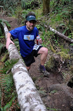
The author enjoys the dregs of an endless Swiss summer.  It's not over yet!


Looking back towards the final pitch up Col de Jaman


Finally I acheived the pass, where I was promptly greeted by 40 mph wind gusts.  Despite pulling my hat down and looking down at my feet the snow still blew directly into my eyes.  I briefly considered the absurdity of running with snow goggles, then realized that this is exactly what many people do.  Meanwhile the snow was burning into the scratches on my legs from the raspberry rose bushwhack from earlier and as always, the descent down to Lake Geneva would take at least an hour.  I never warmed up ride back into Lausanne, but I did leave a rather large pool of water in the train.


On the descent to Lake Geneva with the vineyards of Villenueve yellowing on the hillside.